


Founded in 1830, the Staten Island Farm Colony was once a sprawling several-hundred acre campus. Sister facility Seaview Hospital was planned and built between 1905 and 1938, and at the time was the largest and most expensive tuberculosis hospital in the United States. Together the two facilities defied obsolescence and managed to stay in operation for nearly 150 years, courtesy of a deft ability to adapt and quickly shift their mission.
Eventually the outdated facilities caught up with its operators, forcing the main hospital operations to cease in the mid-1970’s. Redevelopment has sprouted up in the periphery, and a senior center still operates out of the newest buildings, however most structures have been abandoned and left to the elements.
In this post we examine the history and importance of the Farm Colony, Seaview Hospital, and their various structures.
(cover photo courtesy Tabula Rasa)
*
Richmond County Poor Farm
 Prior to the 18th century, support for the indigent was typically handled by the church. During the 1700’s, this began to change when state-sponsored poorhouses appeared around the eastern coastline of pre-revolutionary United States. For New York, this was in 1735 with the construction of the state’s first poorhouse.
The first poorhouse on Staten Island would be constructed nearly one hundred years later, in Richmond County. Property acquisition began in 1803 when supervisors purchased two acres of land near Egbertville. In 1829 the 91-acre Stephen Martino farm was next to be acquired. It was situated on the west side of Brielle Avenue and included an existing farmhouse with several outbuildings.

A Richmond County superintendent was appointed on January 1st, 1830, immediately preceding the opening of the Richmond County Poor Farm.
[ jump to detailed early farm colony site building descriptions ]
archive photos courtesy Staten Island Advance & Staten Island Historical Society
*
New York City Farm Colony
It was originally opened as a poor farm, but the Richmond County site found itself growing to meet the needs of the era. Two years after opening, a cholera hospital was added to the Staten Island retreat. In 1837, the site was fully functioning and nearly self-sufficient. Proceeds from the sale of produce grown at the colony were enough to feed and clothe the residents. The economics left officials ecstatic.

Later that year they expanded capacity by adding a pavilion for the insane.
Growth of the Richmond County Poor Farm accelerated with the explosion of tuberculosis cases in the late nineteenth century. In 1882 the cause of tubercle bacillus was identified by Dr. Robert Koch; eighty years later, the cure would be pioneered at Rutgers University and the Richmond County site on Staten Island.
[ The Adirondack Cottage Community at Saranac Lake was built in 1885 and is considered the first American tuberculosis treatment facility. In 1897, the first hospital for the poor was established in Cincinnati. ]
Tuberculosis came into public view in 1889, when the New York City Department of Health became the first municipal health department to announce the infection as a communicable disease. In 1900 pneumonia was the leading cause of death in New York City – but tuberculosis was a close second, with an estimated 30,000 people afflicted.
 In an effort to better reflect the new services offered, the Richmond County Poor Farm was renamed the Richmond County Farm Colony in 1893. Five years later, Staten Island became a borough of New York City – which left the Richmond County site management and responsibility with the City of New York. Thus, the administrative restructuring left the site with the name of New York City Farm Colony.
New York City established the Department of Public Charities (DPC) in 1895 to handle logistics and management of charitable hospitals, institutions, lunatic asylums, and poor farms. The DPC would later become part of the Department of Corrections, something evident as early as 1902, when the DPC annual report extolled the virtues of the Farm Colony in its annual report:
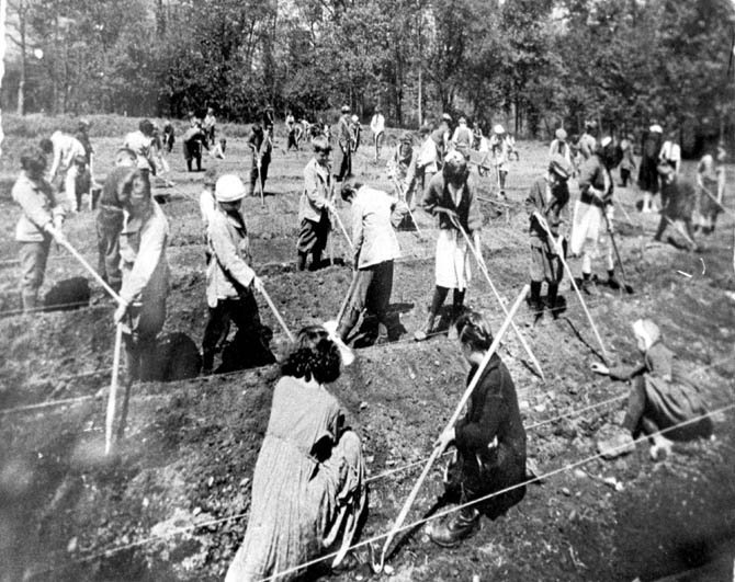
“While the inmates at other institutions … look around and have nothing whatever to do, here they pay for their board twofold by their labor, working on the farm raising vegetables, not only for themselves, but for other unfortunates.”
The 1902 report also noted the Farm Colony, at the time with a population of about 200, could produce vegetables to support 3,000 people.
archive photos courtesy Staten Island Advance & Staten Island Historical Society
*
Farm Colony Growth
For the next two decades the site was continuously expanding. In 1904 a men’s dormitory and additional farm colony resident cottages were added. Over the next five years the site saw the addition of a Board of Health disinfecting plant, women’s dormitory buildings, and a dormitory for male help. By 1911 four women’s pavilions had been added along with a pavilion for the insane.
[ jump to section with detailed later farm colony building information ]
 By the second decade of the twentieth century, sixty-three acres were being cultivated. One hundred and fifty staff monitored the 824 residents, who efficiently farmed fruit and vegetables while raising chickens and pigs; in 1912 they produced $22,887 in food, with surpluses being sent to the Blackwell’s Island institutions.
By this time the farm was supporting 1,211 males and 273 females – but over half the population was over 50 years old; one quarter of the group was over age 70.
A 1914 annual report of the colony outlined the “occupation of inmates”:
“Every inmate who comes to the Farm Colony, except those who are completely disabled, does something, the different occupations being:
Routine cleaning and keeping up of the Plant. Outside work on the farm and grounds. Mechanics, laborers employed in construction. Mechanics employed in the shops as follows:
- Carpenter Shop • Tailor Shop
- Paint Shop • Seamstress
- Tinsmith Shop • Broom Shop
- Blacksmith Shops • Print Shop
- Plastering • Map and Rug Making”
*
Tuberculosis Build-out
 At the turn of the twentieth century there was no cure for tuberculosis, and medical knowledge about the disease was limited. The best-known treatments in 1900 were fresh air, good nutrition, rest, and some sunshine with a pleasant view.
[ The United States’ second municipal tuberculosis hospital was opened on January 31st, 1902, as part of the Metropolitan Hospital complex on Blackwell’s Island. ]
An April 1903 resolution passed by the New York City Council (then known as the Board of Aldermen) noted “tuberculosis is one of the greatest scorges of humanity in this city… that the best and most effective modern scientific methods were out of reach of the poor who are, nevertheless, the greatest sufferers of the disease...” The city tasked the DPC with accommodating this growing need for treatment of consumptives.
The DPC acquired a 25-acre lot in 1903, on the east side of Brielle Avenue directly across from the original Richmond County Farm Colony. The hilltop site belonged to the estate of Charles Schmidt and was known as “Ocean View.”
In 1905 the Board of Estimate and Apportionment approved two million dollars toward the project, one million of which was earmarked for the specialized hospital for tuberculosis treatment. However before the groundbreaking of the hospital, various outbuildings were constructed. Between 1904 and 1906, three cottages were built: One for men, one for women, and one for married couples.
*
Seaview Hospital
State-sponsored tuberculosis treatment on Staten Island officially arrived with the dedication of Seaview Hospital on November 12th, 1913. The finished construction included a staff house, surgical pavilion, nurses’ residence, kitchen and dining hall, power and laundry complex, and a garage and morgue building.

Everything centered around the administration building, a Spanish Mission style facility which anchored what would be the largest specialty hospital in New York at the time. The hospital’s price tag – $4 million dollars – was twice the amount initially allocated in the budget, and the basis for the hospital’s vocal detractors.
However Seaview also enjoyed public support. At the hospital’s dedication the New York Times described Seaview as “the largest and finest hospital ever built for the care and treatment of those who suffer from tuberculosis in any form.”
 The DPC commissioner was also pleased, adding Seaview Hospital was “a magnificent institution that is vast, ingenious, practical, convenient, sanitary, and beautiful, the greatest hospital ever planned in the world-wide fight against the ‘white plague.’ The opening of this hospital is the most important event of this decade in the effort to save 10,000 lives each year, that being the number in the past that have been lost to New York through the ravages of tuberculosis. This splendid hospital, erected by the City of New York at great cost, will serve a most humane purpose in the comfortable care of those who would otherwise be sufferers from neglect and privation.”
It wasn’t long before Seaview Hospital was filled with tuberculosis patients, occupying the open-air porches day and night.
Surgical chest procedures toward the treatment of tuberculosis began to expand in the 1920’s, and Seaview was a pioneer. Incidentally, many physicians on the staff at Seaview Hospital would go on to achieve international recognition in their fields (such as Cornell’s Dr. Pol N. Coryllos and Albert Einstein School of Medicine’s Dr. Leo Davidoff). Before World War II, the best chest surgeons of the day were said to have either trained at Seaview or by someone who spent time at Seaview.
[ jump to detailed information about Seaview Hospital buildings ]

*
Architects & Design
 More than six different architects were responsible for the design at Richmond County Poor Farm and Seaview Hospital. Most followed in the footsteps of the design language set forth by the principal designers: Raymond F. Almirall, Charles B. Meyers, the firm Renwick, Aspinwall & Owen, and its successor firm, Renwick, Aspinwall & Tucker.
The New York City Department of Health asked Renwick, Aspinwall & Owen to submit plans for a hospital at Seaview. At the turn of the twentieth century, the firm was an experienced hand in sanatorium design; in addition to their work at Seaview, the group was responsible for the Adirondack Cottage Sanatorium at Saranac Lake and the Stony Wold Sanatorium at Lake Kushaqua, New York.
Hospital plans called for a symmetrically arranged complex circling around the administration building. An arc-shaped corridor behind the main buildings connected the men’s and women’s dormitories to the kitchen and dining hall. A larger auditorium occupied the center line established by the administration building, bisecting the dormitory wings. To the west, the laundry and power buildings balanced the large nurse’s quarters just east of the administration building.

Due to its tuberculosis mission, Seaview Hospital was built on an elevated location with a southwestern exposure; this offered patients continual sunlight throughout the day in the many open-air pavilions. The Colonial Revival Style was used, its red brick and white stone trim was believed to present a “home-like and cheerful effect.”
From 1906 until 1909, the NYC Department of Public Charities’ official architect was William Flanagan Jr. A heavy workload resulted in many of his tasks being delegated to other architects.
Raymond Francis Almirall was tasked to serve as principal architect at Seaview from 1907 until 1913.

A Brooklyn native, Almirall was also responsible for the Binghamton City Hall, the Fordham Hospital, and Public Bath No. 7. He was thorough in his planning; Ray studied meteorology to understand wind patterns and developed a “shade and shadow table” to display the different amounts of sunlight received by each floor of every pavilion on the longest and shortest days of the year.

Pavilions were narrow and rectangular by design, to allow for maximum cross-ventilation.
Architect Frank H. Quimby shared the DPC’s design duties with Charles B. Meyers from 1914 until 1917, at which time the successor firm of Renwick, Aspinwall & Tucker re-assumed the post. Tracing the hospital’s early design history can be tricky; in some cases the number of architects and designers involved were so numerous, records of who developed what is murky.
Renwick, Aspinwall & Owen plans were commissioned by the Department of Health, while Raymond Almirall had been hired by the Department of Public Charities. This, combined with inter-agency rivalry and litigation between firms, only delayed construction and further clouded the issue.
*
Expansion of Seaview Farms: Merging the Colony & Hospital
In 1915 an administrative shift occurred, merging the New York City Farm Colony with Seaview Hospital to form Seaview Farms. The two sites, separated by Brielle Avenue, were combined to lower costs, unlock efficiency, and expand services (for example, the Farm Colony’s laundry building was re-purposed after the Seaview Hospital laundry facility assumed service for both sites).
At the same time city of New York purchased another two hundred acres of land surrounding the two sites, offering room for more buildings and a buffer of natural woodlands. At the end of 1915, the Seaview Farms complex comprised more than two dozen structures situated across 320 acres. Officials took advantage of the new land and in 1917 built men’s and women’s open-air pavilions, a sanatorium, a group building, and an auditorium/new dining hall.

In 1926 the DPC submitted a proposal to further expand Seaview. The following year a pathology lab was added, and in 1928 a Catholic chapel and rectory became the first religious structures at Seaview. Also in 1928, the DPC added the Richmond County Isolation Hospital.
The patients continued to get older, which made the farming operation more difficult. By the late 1920’s, the self-support ideals of the farm colony and its 1,428 residents were abandoned to better accommodate the growing “haven for old people,” as it was later described in 1932. Thus, the farming activities at Seaview Farms shifted toward craft-making in the late 1920’s.
A DPC report from 1927-28 noted: “The City Farm Colony has shops where the inmates work at brush making, mat making, painting, shoe making, tailoring, gardening and other light work about the institution. They are not obliged to work but are encouraged to do some work to keep their minds and bodies active and some of the inmates receive small salaries or a profit on the sales of the articles they manufacture.”

Another administrative change occurred in 1929 with the recognition of the many non-tuberculosis maladies facing the Farm Colony population. In a move that was perhaps overdue, control was shifted from the Department of Homes for Dependents to the newly formed Department of Hospitals.
In 1930 architect Charles B. Meyers was tasked with designing four new dormitories for the farm colony (west) side of Brielle Avenue. Architect Charles B. Meyers was tasked with the design in 1930 with construction being completed in 1934. Also finished in 1934 was the City Mission Chapel (or “Chapel of St. Luke the Physician”) – and later the Children’s Hospital, finished in 1938, which increased Seaview’s capacity to 2,000 and was the final tuberculosis treatment facility erected at the site.
It was during this time the hospital enjoyed its best operational years, and often ran beyond peak capacity. Seaview was the first tuberculosis hospital to establish a maternity ward, and by the late 1930’s it was treating all forms of the disease, including bone and glandular tuberculosis.
In 1936 the Farm Colony – its capacity now 1428 – had dormitories which reflected “housing that near as possible resembles normal domestic life.”

*
Seaview Hospital Post-tuberculosis
The first major breakthrough in fighting tuberculosis came in 1943, when a Merck-funded research team at Rutgers University developed streptomycin. The antibiotic did not eradicate the tubercle bacillus, but it was able to prevent the disease from reproducing and spreading.
Fittingly, much of the research toward the discovery occurred at Seaview Hospital. Additional treatments were developed later with Seaview help in the 1950’s by Dr. Edward Robitzek and well-known asbestos expert Dr. Irving Selikoff under the guidance of Dr. George Ornstein.
[ Did you know? The United State Army experimented with streptomycin to treat infections. The first patient to receive streptomycin died from his injuries. The second patient survived, but became blind. The third patient survived and fully recovered. His name? Senator Robert J. Dole. ]
The solving of the tuberculosis riddle was bittersweet for Seaview, which still had newer buildings designed specifically to fight the disease. Fortunately, the growing need for senior care significantly aligned with the existing infrastructure. From the late 1940s, hospital administrators gradually began a shift toward geriatric care.
Patients were understandably ecstatic with the developments, confirmed via the Department of Hospitals declaring in its 1952 report:
“Euphoria swept Seaview Hospital. Patients consigned to death at the hands of the White Plague celebrated a new lease on life by dancing in the halls.”
*
Closing of Seaview & Life After Death

Rising cost of care led to a brief (and unsuccessful) attempt in the early 1950’s to re-instate the Farm Colony as an institution serving only the able-bodied. Terminally ill patients were relocated to the Bird S. Coler Hospital on Welfare Island, allowing the Farm Colony to once again operate independently of Seaview Hospital – this time until 1961.
By this time the success of new tuberculosis treatments left Seaview Hospital’s open-air pavilions empty, and only hastened the facility administrator’s push toward senior care. As part of the metamorphosis, new buildings were constructed and old ones abandoned.
The last addition to the site was the J-K building, a 300-bed hospital for geriatric patients finished in 1973 and still in use today. The Children’s Hospital, built in 1938, was abandoned in 1974 – but re-used the following year when the Farm Colony residents were temporarily moved in to the hospital during another organizational re-alignment.
It was 1975 when most of the hospital was shut down for the final time, including the children’s hospital, the dormitories, open-air pavilions, and the farm colony buildings east of Brielle Avenue. The buildings were abandoned and would sit mostly undisturbed for the next forty years.
In 1980 the city briefly dangled the property in front of developers, but activists and residents offered a strong resistance. Eventually the city transferred twenty-five acres to the Parks Department, which then annexed the acreage to Staten Island’s Greenbelt.
Public support for preservation would come in the 1980’s, followed by the official city historic landmark designation for the former New York City Farm Colony and Seaview Hospital sites in a 1985 report by the landmarks preservation commission.

In 1988 the city flirted with developers when the Department of General Services issued a Request for Expression of Interest to developers for the Farm Colony site. The department sought a development partner to build a residential housing.
Called “the Woodlands,” the 150- to 970-unit plans included both rehabilitation of old structures and construction of new ones. Hope faded when a host of onerous city regulations added to the cost and drove potential suitors away.
It was not until 2005 the Seaview Hospital complex of Richmond County, New York was added to National Register of Historic Places.
In November of 2014, it was announced the Landmarks Preservation Commission unanimously backed a proposal to transform forty-five acres of the former poor farm site into “Landmark Colony,” a retail shopping center with 350 units of senior housing.
*
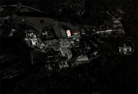
Present Day (2015)
For decades the majority of the buildings were vacant, but the continued operation of a senior center has kept continuous activity on site. Today the site of the former Seaview Hospital offers long-term care via its rehabilitation center, nursing home, and an independent living facility. A volunteer fire company (Metropolitan Fire Association, or “Metro Fire”) still uses Seagrave and Mack pumper trucks to respond to incidents in the historic district.
As is common for abandoned buildings, vandals have broken windows and trespassers have scavenged copper. The grounds are filled with a dense bramble-choking overgrowth, a protective curtain shielding the century-old buildings from view.

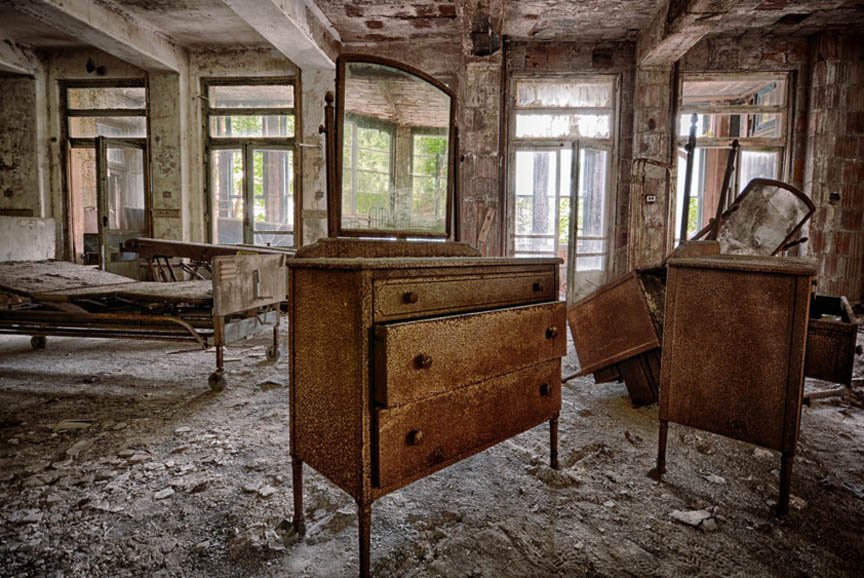
Large dilapidated brick buildings crumble from decades of disuse; foundations remain from sites where previous structures once stood. Inside the old children’s hospital building, collapsing concrete cubicles line an over-sized hallway. Graffiti decorates the walls. Files, newspapers, and toys are scattered atop piles of partially dismantled furniture, all abandoned since 1974. Each of the structures not used after 1975 have furniture, patient files, x-rays, or other medical equipment left behind.

By now, regular readers of Sometimes-Interesting expect to see piles of medical records in abandoned hospitals, and Seaview is no exception – although since this particular site was in constant use, it is perhaps more noteworthy.
What will happen to the old buildings? Given their layout and protected status, restoration and reuse of existing structures is unlikely. Finding suitors to repair and occupy the nearly three dozen abandoned buildings with specialized floor plans and open-air pavilions would be a difficult task.
Also potentially making the site less appealing to suitors, area conservationists fought and won to protect the surrounding woodlands. This was good or bad depending on one’s viewpoint: It protected the Greenbelt network of natural areas and preserved the historic site, but it restricted new development through reduced economic opportunity.
In the meantime, the buildings are protected from man – but not from nature. Absent restorative action, demolition will indeed occur: Slowly, and over time.

So what will happen to the old buildings? The most recent plans push the site toward senior housing.
Will it have the funding and public support past plans lacked?
***
**
Extra Content
**
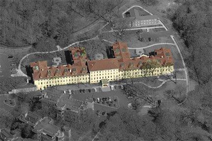
The Structures
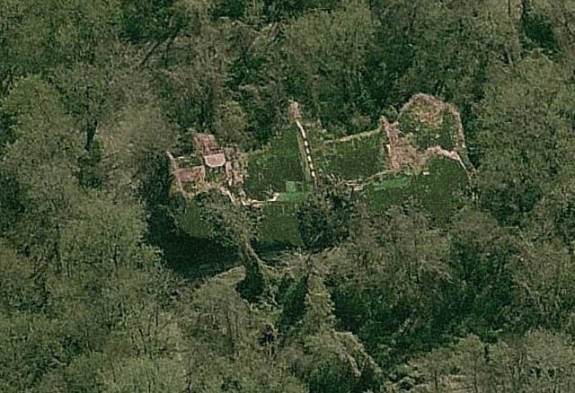
The official historic district consists of thirty-seven buildings. They are located on either side of a north-south axis bisected by Brielle Avenue; because they were designed and built over time, the design languages differ between Spanish Mission, Colonial Revival, or Tudor Revival style.
Richmond County Poor Farm/New York City Farm Colony [1830-1842] Architects: various (map)

Occupies approximately one hundred acres, sloping downhill in each direction away from Brielle Avenue. Buildings were concentrated on the northern half of the property, constructed over a thirteen-year period. Farm Colony structures are located on the west side of the street, the exception being one cottage community building in the Seaview complex on the eastern side of Brielle Avenue.
Men’s Dormitory (Dormitory 1 & 2) [1902-1904] (map)

 Architect: Renwick, Aspinwall, & Owen. 2015 Status: Crumbling. Earliest surviving building on site. This long rectangular structure boasted modern plumbing and was constructed with fieldstone sourced from the site. It measures 154 feet long by 49 feet wide; a basement and attic offer the one-story building additional storage. The center opening was converted to a door circa 1917; roof and framing of east pavilion was destroyed in a 1980’s fire. This building was cited by the architect of a later Farm Colony building as “the nucleus around which the institution should
grow.”

Farm Colony men’s dormitory 1 & 2 Men’s Dormitory 1 & 2 became the prototype for all subsequent dormitories and service buildings. Opened on Thanksgiving Day, 1904, it added 200 male residents which more than doubled the Farm Colony population at the time. Currently it still stands, but it is missing its roof, attic, and floors.
Men’s Dormitory (Dormitory 3 & 4) [1907-1909] (map)
 Architect: William Flanagan Jr. 2015 Status: Demolished. Once sat just east of, and was modeled after, Dormitory 1 & 2. The most significant difference between the buildings was size; Dormitory 3 & 4 measures 187 feet long (versus 154 feet for Dormitory 1 & 2).
Dormitory 3 & 4 was originally designed as a women’s dormitory, but ultimately opened five years after Dormitory 1 & 2 as a second facility for men. Its basement contained the kitchen, dining room, and pantry. The attic and first floor contained single sleeping rooms. Approximately 125 feet northeast sat an octagonal gazebo built some time before 1917. It was later enclosed and used as the farm colony store.
Dormitory 3 & 4 was demolished in the 1980’s when the baseball field next door was renovated. Parts of its foundation might still be visible at ground level.
Dormitory for Male Help [1914] (map)
 Architect: William Flanagan Jr. 2015 Status: Crumbling. The smallest of the dormitories, measures 100 feet by 30 feet; believed to have been designed by Raymond F. Almirall and revised by William Flanagan Jr. Differs from other dormitories by having two stories, deleting the end pavilions, and containing an intersecting center pavilion with large Palladian window in its south wall.
The building has disintegrated at a faster pace than Dormitory 1 & 2. A few walls remain, as well as some parts of the roof. It once had a broad projecting porch which carried four Tuscan columns; other columns have been replaced by modern piers. Metal balconies and fire stairs provided egress from west end of the building. Remains of decoratively articulated end chimneys are crumbling today. Structure is barely visible in satellite view.
Women’s Dormitory (Dormitory 5 & 6) [1907-1909] (map)
 Architect: Raymond F. Almirall. 2015 Status: Crumbling. The westernmost dormitory is a near duplicate of Flanagan’s Dormitory 3 & 4. It was the smaller half of a pair of dormitories on the north side of the colony. The 9-bay men’s dormitory was larger and located just north and 75 feet east of the 7-bay women’s dormitory. As on the other buildings, the end fire stairs were added in 1936. Main entry is on north side, at one time accessed via elaborate twin-columned portico.
Today the shell of the women’s dormitory still stands, however its roof and floors are missing. The male dormitory is long-gone, however it was located northeast of the women’s building, just below the potter’s field (map).


Farm Colony women’s dormitory 5 & 6 Board of Health Disinfecting Plant [After 1898, before 1907] (map)
 Architect: Renwick, Aspinwall, & Owen. 2015 Status: Demolished. Exact build date unknown, however it is known to pre-date the garage/morgue building. Located directly behind the garage/morgue, this smaller structure was used for storage after the farm colony/Seaview merger.
Today it is the site of the Greenbelt Recreation Center’s basketball courts.


Morgue and Garage Building [1914] (map)
 Architect: Renwick, Aspinwall, & Tucker. Northwest addition after 1926, before 1931. Southeast garage addition: 1931, architects: Sibley and Fetherstone. 2015 Status: Mostly demolished. The building was originally just the 150 feet long rectangular block, constructed of brick and fieldstone by Farm Colony residents in 1914. This later formed the middle bar of an “H”, created by additions in 1926 and 1931. Before the additions, the main building had nine garage doors across one side; later renovations removed these, leaving instead three garage doors on the northwest side.
More than a dozen outbuildings once stood around the morgue/garage before being demolished, including a shop, a piggery, and related processing facilities. Today only the 1931 addition (the right side of the garage/morgue building “H”) and a smokestack outbuilding still stand, the former having been remodeled and currently serves as the Greenbelt Recreation Center.


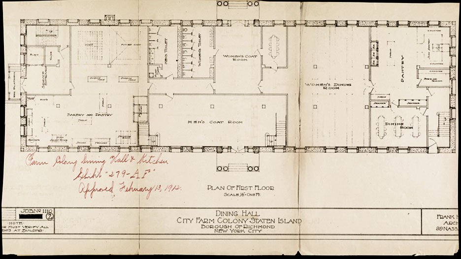
Only the 1931 addition to the morgue & garage building remains today Dining Hall & Kitchen Building [1912-1914, addition in 1935] (map)
 Architect: Frank H. Quimby. 2015 Status: Still standing. Located just 150 feet northwest of the dormitory for male help, the Dining Hall & Kitchen was the largest of the original Farm Colony structures.
The Dining Hall measures 200 feet long by 50 feet wide and has a piano nobile, or elevated main floor which was used as the dining area.
The dining hall is one of the few original Farm Colony structures to still have its roof. Copper roof cladding has been removed, however original skylights and the gable-shaped skylights on the east ridgeline are still visible.


In the 1930’s a long ramp was added to provide wheelchair access to elevated entry. The brick shaft in the center of the north flank was a freight elevator, also a mid-1930’s addition.


The Farm Colony dining hall & kitchen building Laundry & Industrial Building [1914, addition in 1935] (map)
 Architect: Frank H. Quimby. 2015 Status: Still standing. Westernmost structure in Farm Colony group, sits about 200 feet southwest of the dining hall building.
When Seaview Hospital laundry began to service both facilities in 1917, this building was converted to shops for broom and mat making, carpentry, carpeting, printing, and tailoring. Today it also deteriorates, however with a roof still intact, it has fared better than the dormitories.

The NYC Farm Colony laundry & industrial building Pavilion for the Insane (later converted to Nurses’ Residence) [1907-1910, addition from 1932-1938] (map)
 Architect: Raymond F. Almirall. 1932-38 addition: William L. Rouse. 2015 Status: Still standing. The “insane pavilion” is a rectangular structure directly south of Dormitory 5 & 6.
Originally completed in 1910, it more than doubled in size with the completion of a two-story plus basement addition in 1938. The original roof and porches have since been removed. Some of the original 1910 masonry is still visible; however because it was re-purposed as employee housing, the addition was designed more utilitarian.


Farm Colony Pavilion for the Insane/Nurses’ Residence Farm Colony Dormitories A, B, C, D [1930-1934] (map)
 Architect: Charles B. Meyers. 2015 Status: Still standing. Built to meet an increasing demand, these four staggered buildings were constructed on former Farm Colony farmland. They were also the first structures on site specifically designed for senior care.
Dormitory A is the westernmost building; Dormitory D sits farthest east, just 50 feet from Brielle Avenue. Dormitory B sits to the east of Dormitory A; Dormitory C sits to the west of Dormitory D. They were built in a Georgian Revival style instead of the previously used Colonial Revival, and staggered to provide maximum light and air. The south side of the dormitories have end pavilions, which capture light and grand vistas offered by the large, southern-facing windows.


Farm Colony Dormitories A, B, C, & D These dormitories were the last major buildings constructed at the Farm Colony, but the complex was to remain in use for almost another forty years. Roofs are intact, but were robbed of their copper cladding in the 1980’s. Today the buildings are all still standing, however their condition is quickly deteriorating. As some of the easiest buildings to access (right off Brielle Avenue), they have fallen victim to graffiti and vandalism.
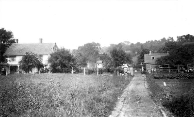
Farm Colony Cottage Community [1903-1916] (map)

 Architect: Renwick, Aspinwall & Owen. 1916 cottages: Charles B. Meyers. 2015 Status: Only one cottage remains, currently being restored. The thirty acre lot on the east side of Brielle Avenue – today located directly north of the Seaview Hospital complex – was used for the Farm Colony’s cottage community, and was acquired by the state in 1903.
The cottage colony was never developed on the scale originally envisioned. After the first three were built in 1904, just two additional cottages were constructed. The first three cottages (one for men, one for women, and one for married couples) were built between 1904 and 1906 around a planned road system.
An assessment made in an early Department of Public Charities annual report stated that the cottages represented a “far more humane and satisfactory way of caring for aged dependents.”


Only one cottage remains (c. 1916) in the Farm Colony Cottage Community. An assessment made in an early Department of Public Charities annual report stated that the cottages represented a “far more humane and satisfactory way of caring for aged dependents.”

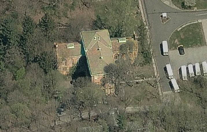
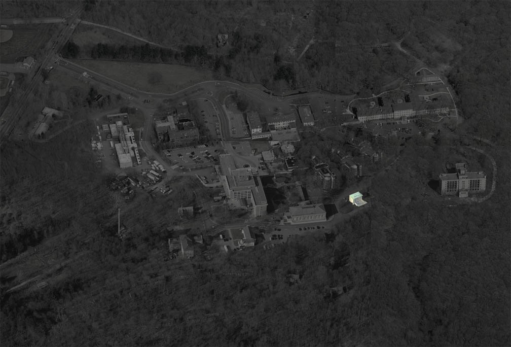
 Charles B. Meyers designed the two cottages which were built in 1916 – one of which was used as the Seaview Hospital director’s residence in the 1930’s. This east-facing cottage (pictured above) is the only one to have survived, and is being restored.
Today the site has been bulldozed for new construction of “Brielle,” a senior center (pictured at right).


*
Seaview Hospital Complex [1910-1973] Architects: various (map)

The Seaview complex occupies the east side of Brielle Avenue. Buildings were concentrated on the center of the property, some constructed more than fifty years apart. Of the buildings’ style, principal architect Raymond F. Almirall said:
“The architecture is modern and of no historical or geographical style. A consistent effort has been made to express hospital purpose by simplicity, and by light, air, abundant veranda space and cheerfulness… Such design may be thought to better emphasize the hospital idea than the apartment house or semi-monumental adaptions that greet us so frequently in this country… To furnish plain wall surfaces and eliminate costly and dirt-harboring rusticated brickwork, projecting stone bands and cornices, which supply the dust to be blown into conveniently located windows; to provide a sufficiency of veranda space on each floor to accommodate every bed of each ward, and to eliminate the oppressive and dismal appearance of the building and its approaches, is perhaps novel, though of great practical advantage…”

Almirall also introduced innovative efficient mechanical systems, such as the paralleling below-ground systems linking the corridor on the north side of the complex and the elliptical corridor of the patient pavilions. Ray explains:
“From the south side of the power house and laundry building, and beneath the covered corridor connecting this group with the administration building, a road extends for the delivery of supplies to the service building from the courtyard between it and the administration building where the road terminates. Below the elliptical corridor extend two separate tunnels of full horizontal width. In the upper one there will operate the food conveyor, in the lower tunnel are laid the tracks for a flat electrically propelled car for general service on one side,’ and on the other are arranged vertically the main supplies of water, heat, electricity, and refrigeration. The tunnel for the food conveyor connects by elevators with the ward service pantry of the central kitchen and by lifts with each ward diet kitchen. The lower tunnel connects directly with all buildings with which the enclosed corridor connects, except the staff house, administration building and surgical pavilion…”
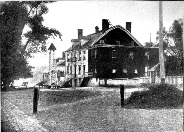
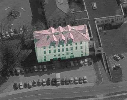
Administration Building [1913] (map)
 Architect: Raymond F. Almirall. 2015 Status: Still standing. Center structure in group of five buildings fronting roadway; a wisteria-covered pergola sits off the northwest corner of the building. A manicured island now sits where the former landscaped courtyard once stood. When finished in 1913, the administration building housed offices and patient-reception facilities.
The south face has two one-story wings which extend outward. One wing contained the examination room and the other the dressing room. Pink walls were a later modification; originally the walls were light gray. Today the building is being used by the still-operating Seaview Hospital Rehabilitation Center & Home.


Seaview Hospital Administration Building Staff Residence [1913] (map)
 Architect: Raymond F. Almirall. 2015 Status: Still standing. The staff residence is the rectangular building just west of the administration building. It shares the red terra-cotta tile roof design as the administration building, but is easily discernible as a residence by the presence of eight attic windows.
A large one-story porch that once fronted the western elevation was demolished to make room for a parking lot. The eastern flank of the staff residence shares the pergola with the administration building.


Seaview Hospital Staff Residence Surgical Pavilion [1913] (map)
 Architect: Raymond F. Almirall. 2015 Status: Still standing. To the east of the administration building lies the surgical pavilion, the smallest of the three buildings. Two bays were added to the southern end in the late 1930’s, which explains the lack of window symmetry.
Unique to this building is the flat-roofed enclosed porch attached to the north face. Its windows are larger than those of the staff residence and terminate at the top of the low-molded base that extends around the building. Like the administration building and staff residence, the surgical pavilion is in fair condition.


Seaview Hospital Surgical Pavilion Women’s Pavilions (Pavilions 1,2,3,4 & elliptical connecting corridor) [1909-1911] (map)
 Architect: Raymond F. Almirall. 2015 Status: Poor condition, but still standing. These four structures lie on the eastern side of the north-south axis which bisects the complex, and actually pre-date the administration building group. At one time, a symmetrical group of four men’s pavilions fanned out across the other side of the north-south axis, however these were demolished in the 1970’s to make way for the newer J-K Building, which is still in use today.
The pavilions are large four-story structures built with hollow-tile block and reinforced concrete. Five-sided bays, which each housed six ward beds, project from the middle of each building. Attached to the southern end of each pavilion is a four-story solarium bay, once used as open-air sleeping porches. Also attached to the southern end of each pavilion were modern fire-stair towers – these were a code-enforced addition in later years. The pavilions once shared the red terra-cotta roofs with the other structures, however in the years since it has been replaced. The northern end of each pavilion was six bays in length and housed the kitchen, bathrooms, storage, and linen rooms. The southern end was earmarked for patients; fourteen beds on each floor.


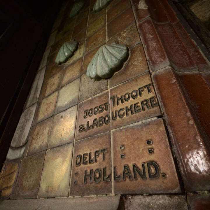
(ceramic tile frieze photos courtesy Tabula Rasa)
The most unique feature of the women’s pavilions is the ornamental ceramic tile frieze, a full-length depiction of nurses and physicians, complete with red crosses and raised scallop shells (pictured above). It was the work of Joost Thooft & Labouchere, a Dutch company known for its pottery and tile work. The mosaic sits beneath the projecting eaves, and was partially obscured from view when the enclosed porches were added.
On the exterior, glazed tiles decorated with white flowers aesthetically divide the floors. Each pavilion’s main entry was via the elliptical connecting corridor. Above the door openings are glazed terra-cotta panels which contain the pavilion number, flanked by foliate designs.


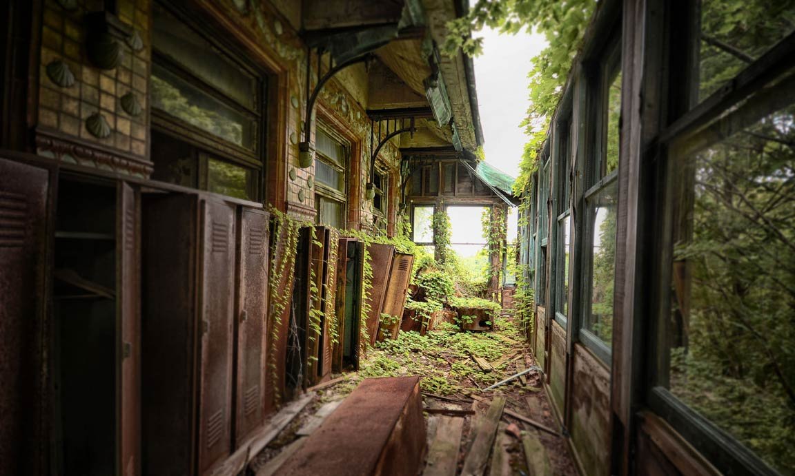
Seaview women’s pavilion (courtesy Tabula Rasa) Aside from a brief stint as temporary housing in the 1980’s, these buildings have not been regularly used since the 1970’s. Today they are falling apart; broken glass covers the floor, rotted wood creaks when pressed, and rusted railings crumble when touched.
Random artifacts still litter the halls of these buildings; it’s not unusual to see old beds, gurneys, and wheelchairs. The copper downspouts, flashing, and soffit which once adorned the buildings were pilfered by scavengers in the 1970’s, which also opened the buildings to severe water damage.


Seaview Hospital Women’s Pavilions Nurses’ Residence [1913, addition in 1932] (map)

1932 addition in yellow Architect: Raymond F. Almirall. 1932 addition: Adolph Mertin. 2015 Status: Still standing. A landscaped garden once separated this building from the surgical pavilion – today replaced by a parking lot. This building sits just east of the surgical pavilion and boasts a porte-cochère at its west end.
The nurses’ residence was built in two stages: The first structure, finished in 1913, consisted of the western end of the building. It was a long rectangle with unequal-length wings extending from its north face. A 1932 expansion (pictured above in yellow) to its east more than doubled its size, by adding a symmetrical residence with unequal-length wings extending from its north face, and a center pavilion connecting the two buildings.
The elevation change to the south results in the basement level appearing as a ground floor level along the rear. A large porch with three French windows survives on the north face of the eastern wing; a matching porch once existed on the north face of the western wing, but it was later removed.


Seaview Hospital Nurses’ Residence Power House, Laundry & Ambulance Complex [1912, addition in 1935] (map)
 Architect: Raymond F. Almirall. 1935 addition: Charles B. Meyers. 2015 Status: Deteriorating, but still standing. The power house complex sits about 200 feet west of the staff residence and is the first building to be seen from the entry road after turning off Brielle Avenue. It was originally an L-shaped structure, the north-south wing housing power, the east-west wing home to laundry. Designs were drawn to expand this building with a symmetrical addition – similar to the nurse’s residence expansion – however these plans were never fulfilled.
The power house is easily identifiable because it generally lacks windows; the laundry wing, on the other hand, has very large windows.A tall smokestack once extended from the northeastern corner of the power house, however this was removed years ago for safety. Directly east of the former stack location sits the ambulance house, a one-story structure with segmentally-arched windows. The original vehicle entrance was on the north side, now covered by a later addition. Charles Meyers was responsible for the west flank addition of the power house. It runs east-west as does the laundry, and included its own smokestack just south of the building – also since removed.
The power house and its addition were not included in the site protection designation, but they still boast an impressive collection of century-old mechanical gear: Boilers, coal bunkers, conveyors, and furnaces remain entombed in a decaying sarcophagus.


Seaview Hospital Power House, Laundry, and Ambulance Building Seaview Kitchen & Dining Hall Group [1912-1914] (map)
 Architect: Raymond F. Almirall. 2015 Status: Still standing. The kitchen building and the group of attached dining halls formed the center of the original Seaview Hospital complex. It occupied what was at one point an enclosed landscaped courtyard (with help from the elliptical corridor linking the women’s pavilions). Overgrowth fills the courtyard today.
A dining hall, which once sat to the west of the kitchen, was demolished in the 1970’s to make way for the newer J-K Building. The octagon structure just to the south of the administration building is the kitchen (pictured below in blue), which sits atop the institution’s bakery, located in the basement. An attic-level bank of windows encircles the vaulted ceilings and pours light into the first-floor kitchen. A ring of vent stacks line the roof. The kitchen is ringed by ancillary facilities (bread rooms, dish pantries, serving pantries, and scullery).Two windowless blocks attached to either end of the south wall contain elevators for the food distribution system. Almirall explained the kitchen’s elaborate system as such:
“The electrically propelled food conveyor, automatically controlled from the ward service pantry of the central kitchen, will within a few minutes carry food to any diet kitchen and signal its arrival. It may be returned to the starting place or sent to another floor by the nurses or recalled by the dispatcher. It must be remembered that this carrier travels vertically in an elevator and a lift as well as horizontally in the tunnel. This carrier has since been patented.”


The one-story corridor extending north from the kitchen leads to the staff dining hall (pictured above in yellow), also one-story, but rectangular in shape and white in color. A slightly bowed corridor, once the dining hall for female patients, extends east from the kitchen. An elaborate arrangement of porticoes and enclosed corridors provides access to the dining wing from the patient pavilions. A pyramidal-roofed portico is incorporated into the elliptical corridor between pavilions two and three; it served as the entrance to the dining hall from the four female pavilions.Seaview Men’s & Women’s Open Air Pavilions [1917] (men’s map) (women’s map)

men’s open air pavilions Architect: Renwick, Aspinwall & Tucker. 2015 Status: Crumbling, missing floors & roofs, most in danger of collapse. Open air pavilions were a major part of the Sanatorium addition to Seaview in 1917. The pavilions are long, rectangular two-story structures constructed of red brick and roofs of green tile.
They comprised two separate rings of buildings: Twelve pavilions for the men just south of the Seaview complex, and nine pavilions for the women, just north of the nurse’s residence. At one time an oval-shaped roadway linked the twelve men’s open air pavilions. Two pavilions have since been demolished, leaving ten. Inside the ring, manicured grass walkways used to lead back and forth between the pavilions; today this is covered by dense overgrowth.


Seaview Hospital men’s open air pavilions 
women’s open air pavilions The women’s open air pavilions pre-date and sit approximately 150 feet north of the nurse’s residence addition. Each pavilion faces south and is connected by a rough circular roadway. Overgrowth covers the numerous paths which once crisscrossed the central island.
Pavilions were two-story T-shaped buildings with a center section containing lockers and toilets; the southern ends contained the day rooms. In the wings were the open air dormitories.
Buildings were constructed on various grades, so the main entry to the women’s pavilions were constructed at varying heights.


Seaview Hospital women’s open air pavilions Group Building [1917] (map)
 Architects: Edward F. Stevens & Renwick, Aspinwall & Tucker. 2015 Status: Still standing. This Georgian-Revival building was part of the 1917 Sanatorium build-out at Seaview Hospital. It housed men’s examination and treatment rooms, a pharmacy, recreational facilities, craft shops, a barber, a tailor, woodworking shops, a library, a billiard room, and a linen distribution room.
The Group Building is T-shaped with low parapet walls, ridge line skylights, and large chimneys at the end of each wing. Its entrance is reached via a long flight of wide steps.


Seaview Hospital group building Auditorium or “New Dining Hall” Building [1917] (map)
 Architects: Edward F. Stevens & Renwick, Aspinwall & Tucker. 2015 Status: Still standing. This building sits south of the kitchen and southwest of the women’s pavilions. Today known as Colony Hall, it was once used as a men’s dining facility and recreational hall for men and women. Like the Group Building, the New Dining Hall was built in Georgian Revival style: Constructed of a pale yellow brick in a Flemish bond.
One-story porticoes allow entry on the northern and western elevations. The northern portico contained a large serving pantry and women’s coatroom; the western portico contained the men’s coatroom. The building’s original green roof tiles have since been replaced with light gray asphalt. Eight of the nine arched openings along the southern face contain multi-paned French doors flanked by full-length windows. The ninth archway does not extend to the base of the floor because it opens onto the elevated stage inside, on the east end of the dining hall.


Seaview Hospital auditorium/new dining hall building Pathology Lab [1927-1928] (map)
 Architect: Charles B. Meyers. 2015 Status: Still standing. This building was originally slated to be part of the power house addition in 1917, however budgetary measures pushed construction back until 1927.
By this time, the hospital had grown around the power house, so the pathology lab was relocated to a steep slope approximately 150 feet east of the new dining hall.


Today the former pathology lab is home to the Staten Island Ballet. Although it was built ten years after the group building and new dining hall, this Georgian Revival structure is adorned with the same pale brick, limestone trim, and green roof tiles. Viewed from the north, the building appears as small two-story structure; from the southern elevation, the cavernous basement is exposed yielding a much larger building.
Today this building is still in use and currently occupied by the Staten Island Ballet.


Seaview Hospital pathology lab Catholic Chapel & Rectory [1927-1928] (map)
 Architect: Robert J. Reilly. 2015 Status: Still standing. Interestingly, it was not until 1928 that Seaview acquired a structure which served a purely religious purpose. Records show plans for a chapel were included in Almirall’s original hospital plans; however the postponed construction until 1927 suggests a similar financial-driven delay.
The Catholic Chapel and Rectory building sits in between the Group Building and the new dining hall, about 75 feet south of the new J-K Building. This small L-shaped structure uses the same Spanish Mission style with red terra-cotta roof favored by Almirall in the earlier buildings. The base of the L is the two-story rectory, attached to the southern end of the building. Exterior walls are finished in a rough concrete stucco. Today the chapel and rectory serve as parking for Seaview Hospital’s van and shuttle service.


Seaview Hospital Catholic Chapel & Rectory Richmond County Isolation Hospital [1927-1928, addition 1932] (map)
 Architect: Sibley & Fetherstone. 2015 Status: Still standing. The isolation hospital is the easternmost building at Seaview, located south of the main entrance and just 75 feet east of Brielle Avenue. A gated entrance on Brielle is now permanently closed. It was originally operated by the New York City Department of Health, and worked in concert with the disinfecting plant across the road.
The original structure was rectangular; a 1932 addition formed the T on the building’s north side. It is still in use, although today it houses administrative offices.


Richmond County Isolation Hospital at Seaview City Mission Chapel or “Chapel of St. Luke the Physician” [1934] (map)
 Architect: Frances DeLancey Robinson. 2015 Status: Still standing. Commissioned by the New York Protestant Episcopal City Mission Society in 1934, the City Mission Chapel was Seaview’s second religious structure. It sits approximately 150 feet north of the Group Building, and to the west of the newer J-K Building.
The City Mission Chapel differs from the Spanish Mission Catholic Chapel by following the neo-Gothic Revival style. The cornerstone bearing the date — 1934 — is located north of the entry portico. Above the eastern-facing windows are brackets and sill that supported a bell; it went missing some time before 1985.


Seaview Hospital City Mission Chapel Children’s Hospital [1935-1938] (map)
 Architect: Adolph Mertin. 2015 Status: Poor condition, but still standing. The tallest and arguably most well-known building at Seaview is Adolph Mertin’s Children’s Hospital, the last major tuberculosis facility built at Seaview, which opened in 1938.
The Children’s Hospital sits somewhat isolated from the other structures on the southeast portion of the property. Two basement stories lay beneath four traditional levels, offering a six-story appearance to the southern elevation. A parapet-walled circular approach drive leads to the building’s main entrance on its north side.The hospital was modernistic in style and built with cream-colored brick with sparse limestone trim.
Inside, some of the original metal grille work balcony railings remain; however the metal facings located between the porch floors have been removed. Rounded solarium bays are located on the ends. Thin, masonry-clad supports visually break up the vast open-air porches on the wings. When finished, the Children’s Hospital raised Seaview’s overall capacity to nearly 2,000. A year after Seaview Hospital closed in 1974, the remaining Farm Colony residents were moved into this building temporarily until they were able to be placed elsewhere.


The Children’s Hospital at Seaview Seaview Hospital Building (J-K Building) [1968-1973] (map)
 Architects: Brown & Guenther. 2015 Status: Still operational. Three new buildings completed in 1973 required the demolition of the four original men’s pavilions, their elliptical connecting corridor, and the west dining wing. The J-K Building is the large, modern five-story orange brick building with gray trim. It is square in shape with two rectangular wings extending north and south.
A one-story wing extending to the east contains a chapel, discernible via an irregular shaped roof. An enclosed corridor now connects the J-K chapel to the new dining hall building. The third structure, a generating plant, was constructed immediately west of the main kitchen building.


The J-K Building at Seaview Hospital Various Service Buildings [1914-1942]
Architects: Various. 2015 Status: Most demolished; some still exist, but crumbling. In addition to the named buildings on this page, the Farm Colony/Seaview site contained more than a dozen other smaller buildings which served in various capacities:
- A variety of wood frame stables, barns, and animal pens.
- Several small service and storage buildings are clustered on the west side of the complex. They are located north and south of the road which leads westward toward the southwest corner of the district, and the area where sixteen temporary patient pavilions once stood. Constructed of various materials (stone, brick, wood), they include a greenhouse, shops, and storage sheds.
- A shop building was added sometime between 1911 and 1917. A simple one-story structure built of fieldstone, it is located about 125 feet southwest of the pavilion for the insane. Inside, stepped walls divide three shops: Printing, tinsmith, and plumbing. Each shop is provided with a separate entrance; all are on the west side of the building.
- The 1930 one-story brick incinerator building and adjacent moderately tall, smoke stack, situated across from the southeast corner of the morgue/garage building (map)
- A 1941 one-story brick structure possibly housing electrical equipment lying to the north of the dormitory for male help
- A collapsing brick and wood shed located to the west of the laundry/industrial building
- A large corrugated metal warehouse which stands immediately to the north of dormitory B
- Several apparently older structures of several materials — stone, brick, concrete-block and wood — located to the north of the service road behind dormitories A through D
- A deteriorated wood garage lying opposite the southeast corner of the Pavilion for the Insane
- On the east side of the power house complex: A one-story brick building attached to the south side of the original ambulance house housed refrigeration equipment
- A one-story gabled wood frame shed was added to the north side of the ambulance house.
- A small 1941 brick structure on the north side of the exit roadway onto Walcott Avenue
- A gatehouse and visitors’ reception center located on the north side of the main entry road and fronting Brielle Avenue is an undistinguished structure dating from 1942
Potter’s Field [1830-1905] (map)
2015 Status: Still there, but overgrown. An unmarked cemetery, known as a potter’s field, sits in the northernmost corner of the site. Hidden in a wooded area today, it sits behind the Farm Colony dormitories to the south and abuts Walcott Avenue to the north. It is roughly rhomboidal in shape and measures 450 feet by 450 feet. An alley of silver maple trees once led to the cemetery from the south, but most of this was destroyed when Dormitories A through D were built.
Reportedly still visible at ground-level: The foundation of an early morgue that once sat at the southernmost corner of the cemetery. Marble stones of meager sizes act as grave markers, scattered and buried in overgrowth. The potter’s field is believed to have been in use as recently as 1905.


***
